In 2022, as Hurricane Fiona unleashed relentless rain on Puerto Rico, the Puerto Rico Landslide Monitoring Network—a network of 18 autonomous, remote data-acquisition stations designed and installed by the Puerto Rico Landslide Hazard Mitigation Office—played a critical role. While the storm battered the island with as much as 30 inches of rain, these stations detected alarming signs: localized heavy rainfall, surging soil moisture, and rising groundwater. For Dr. Stephen Hughes and his team, these conditions signaled an elevated risk for landslides across the island.
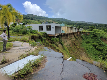
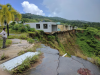
Armed with near real-time data, Dr. Hughes noticed a specific area of the island with exceptionally heavy rainfall and dangerously elevated soil moisture. Hughes reached out to a local community leader to inform him of the hazardous conditions. One neighborhood on the east side of the island, located in this high-risk area, was evacuated just before a massive landslide buried a roadway and one home. Quick action helped protect this home's residents who had vacated just hours earlier.
Thanks to the Puerto Rico Landslide Hazard Mitigation Office’s access to this data and the quick action of local community leaders, no lives were lost. Positive outcomes such as this aren’t due to luck; they’re the result of years of planning and preparation. The Puerto Rico Landslide Hazard Mitigation Office proved the network's life-saving potential, highlighting the critical role of measurements and technology in protecting regions vulnerable to natural disasters. With extreme weather, systems such as these are more essential than ever.
What is the Puerto Rico Landslide Monitoring Network?
The Puerto Rico Landslide Monitoring Network is an innovative initiative led by Dr. Hughes through the Puerto Rico Landslide Hazard Mitigation Office, which is part of the Department of Geology at the University of Puerto Rico at Mayagüez. This initiative is supported by the United States Geological Survey (USGS) Landslide Hazards Program, the Puerto Rico Science Trust, and the National Oceanic and Atmospheric Administration (NOAA) Caribbean Climate Adaptation Network (CCAN) group. This project leverages durable technology to monitor landslides and helps protect Puerto Rico’s vulnerable communities.
At its core, the Puerto Rico Landslide Monitoring Network is more than just technology. Rather, it represents a collaborative effort to make Puerto Rico safer by carrying out continuous research and community engagement activities related to local landslide hazards with a vision to expand landslide hazard science and preparedness for the island.
Challenges
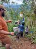
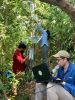
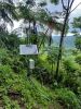
Building the network was no small task. Puerto Rico’s rugged, mountainous landscape—with more than 60% of the island covered in steep terrain—presents unique challenges when it comes to installing and maintaining a network of monitoring stations across such a large, densely vegetated island. The tropical climate adds to the complexity. Each monitoring station must withstand not only the island’s harsh weather, including high humidity and heavy rain, but also the jungle’s rapid growth, which regularly requires pruning to keep the stations in reliable working condition.
Data transmission from isolated areas poses yet another challenge. In a region where one in three people live in high-risk landslide zones, ensuring reliable communications isn’t just a technical issue but a matter of protecting lives. The Puerto Rico Landslide Hazard Mitigation Office team is focused on finding a solution and has made remarkable strides forward, laying the groundwork for enhanced safety across the island. With an improved awareness of elevated landslide risk, communities are better informed and safeguarded.
The positive impact of the Puerto Rico Landslide Monitoring Network is undeniable. After Hurricane Maria triggered more than 70,000 landslides in 2017 and Hurricane Fiona set off hundreds more in 2022, the work Dr. Hughes and the Puerto Rico Landslide Hazard Mitigation Office perform serves not only as an academic tool to better understand landslide conditions, but as an irreplaceable early-detection system for more than one million Puerto Ricans living in harm’s way.
How does it work?
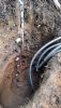
The Puerto Rico Landslide Monitoring Network was designed in collaboration with the USGS and uses a Campbell Scientific CR1000X datalogger and AVW200 vibrating wire interface to monitor vibrating wire piezometers for groundwater pressure. Precipitation is measured using the TE525 tipping bucket rain gauge. Soil moisture at multiple depths is measured using the METER TEROS-10. A Campbell Scientific fiberglass enclosure houses the data logger, vibrating wire interface, battery, and RV50X cellular modem. In addition, a CS210 Enclosure Humidity Sensor measures the enclosure’s internal humidity, letting maintenance personnel know when a visit should be scheduled to change the desiccant and perform other maintenance tasks.
Graduate and undergraduate students from the University of Puerto Rico at Mayagüez have helped install new stations and been involved in ongoing maintenance visits, creating a unique field-based learning laboratory under Dr. Hughes’ guidance.
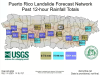
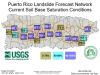
The network currently consists of 18 monitoring stations strategically located in areas of high to very high landslide potential with each station serving as an analog for the conditions in its surrounding area. Data are visually monitored by a graphical screen that provides near real-time updates on an island map created using Campbell Scientific’s Real-Time Monitoring and Control (RTMC) Software. By monitoring these conditions, the Puerto Rico Landslide Hazard Mitigation Office is better able to detect the conditions that trigger landslides, giving communities the warning they need to act before disaster strikes.
What’s next for the Puerto Rico Landslide Monitoring Network?
Looking forward, the Puerto Rico Landslide Hazard Mitigation Office team aims to expand their network of monitoring stations and enhance their forecasting capabilities, ensuring that the system can provide even more accurate and timely warnings. Collaboration with local communities remains a priority, as does advocating for cost-effective solutions to ensure the project's long-term sustainability.
For those eager to stay updated, the Puerto Rico Landslide Hazard Mitigation Office offers real‑time data and resources via their website. For now, the focus is on celebrating success stories such as Hurricane Fiona, where technology and teamwork saved lives.
Find out how real-time data helped warn communities and prevent tragedy during Hurricane Fiona, saving lives through science and teamwork in our "Early Warnings That Saved a Community" video.
Do you want to reduce uncertainty and operate efficiently? Our application engineers and sales team are here to help. Reach out to discuss your current projects, and we'll work together to find the best solutions for you.
Case Study Summary
Application
Monitoring landslide risk, prompting early evacuationLocation
Puerto RicoProducts Used
CS210 RTMC CR1000X AVW200 RV50X TE525-LParticipating Organizations
Puerto Rico Landslide Hazard Mitigation OfficeMeasured Parameters
Precipitation, soil moisture, groundwater levelRelated Website
Puerto Rico Landslide Monitoring Network, Puerto Rico Landslide Hazard Mitigation Office, Caribbean Climate Adaptation Network (CCAN)View the PDF