How to download your free CCFC software update
by Danelle Fash | Updated: 01/10/2018 | Comments: 3
Blog Topics
Area / Application


Product Category


Corporate / News
Search the Blog
Blog Languages
Subscribe to the Blog
Get an email when a new article is posted. Choose the topics that interest you most.
Suggest an Article
Is there a topic you would like to learn more about? Let us know.
At Campbell Scientific Canada, our mission is to deliver our clients the best measurement possible. To do that, we need to ensure the equipment we manufacture remains valuable throughout the life of the product. That’s why we’re constantly developing new software upgrades for our clients, free of charge.
All of us here at CSC are incredibly excited to announce the latest free software upgrade for our CCFC Field Camera, which includes:
- faster 5MP image captures,
- increased lens positions, and
- normalized difference vegetation index (NDVI) image capture capability.
How is NDVI Data Captured and Utilized?
We love when our customers tell us how they’re using our equipment, but more importantly, we appreciate when our customers tell us what they wish their equipment could do. The request for NDVI capability was brought to us by customers interested in crop phenology - the analysis and understanding of crop development. According to NASA,
In other words, NDVI visually demonstrates how well a plant is photosynthesizing. This data is crucial for evaluating the productivity of crops and proper crop management, such as drought monitoring and fungicide application.
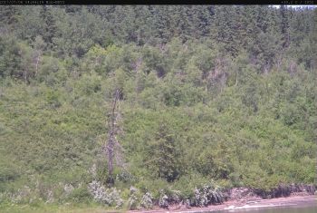
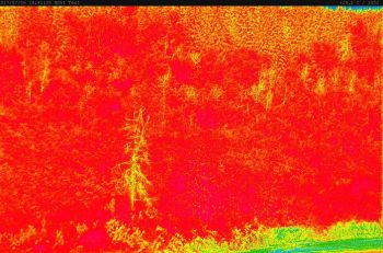
|
Standard image capture of healthy & unhealthy vegetation |
NDVI further enhances unhealthy vegetation |
Prior to this update, our customers utilized our CCFC cameras to visually monitor crop health, however, the image value in this particular area of application was lacking. And if a field camera wasn’t available, they relied on satellite imagery or small drone mounted cameras for NDVI capture.
As you can imagine, NDVI satellite imagery has the unique ability to provide data across large land masses in a single image. NASA collects NDVI images from around the globe, and makes them publicly available on their website. While this data is interesting, it doesn’t provide specific enough data for individual application.
Drone mounted cameras, on the other hand, have the benefit of providing more localized data to the end user, but lack image consistency. Adverse weather conditions, such as intense wind, rain and freezing temperatures, inhibit the use of drones altogether, while manual operation leaves room for error, creating differences in image placement, timing, and quality.
The Benefit of NDVI Cameras
While both satellite and drone imagery can provide valuable information, NDVI cameras have the capacity to ‘ground truth’, or corroborate, those images. By incorporating NDVI cameras, the end user will have consistent access to high-quality, localized data.
Our Quick Eye system equipped with CCFC camera with NDVI functionality, is perfectly designed for this type of environmental monitoring. The fully automated Quick Eye can be deployed in less than 5 minutes in any location, regardless of how remote, and is manufactured to withstand the most extreme temperatures and weather conditions.
Download Your Free NDVI Software Upgrade
To start collecting your own NDVI imagery, simply follow these steps:
- Click here to download the software update file.
- Open your CCFC dashboard. In the left-hand menu, navigate to Settings > Advanced > Update.
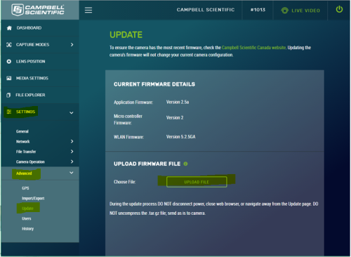
- Select “Choose File” and upload the software file.
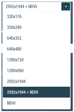
- To enable NDVI on our camera, navigate to “Media Settings” in the left-hand menu and select either “2592x1944 + NDVI” to capture both standard and NDVI images, or “NDVI” to capture NDVI images only.
Additionally, you also have the ability to include sensor data pulled from your datalogger, into a banner along the top or bottom of your NDVI images. For instructions on how to set that up, see our CCFC - SendVariable Instruction update.
If you experience any technical difficulties downloading or enabling your NDVI software update, please contact our technical support team.
We hope you enjoy this latest software upgrade from our CSC team, and the added value it brings to your data.


Comments
AgroCam | 04/10/2019 at 12:57 PM
Nous avons une solution simple et économique pour la cartographie NDVI:
https://www.agrocam.eu/
chengchen | 04/16/2019 at 08:09 PM
Can ccfc output the ndvi value to the TOA5 datatable?
akeys | 03/20/2020 at 08:31 PM
test
Please log in or register to comment.